Tuesday, 31 July 2012

PHOTOGRAPHS TRANSIT OF PANAMA CANAL

Approaching The Panama Canal Entrance From the  Atlantic At 5am
Panama Canal Entrance at Dawn
Full View Of The Panama Canal Entrance Frol the Atlantic Side
Looking Back towards the Atlantic From the Third Lock Showing Following Ships Entering Locks
View of First Lock Atlantic Side
View of Second Lock From Atlantic Side
View of Third And Final Lock Leading to Gatun Lake Atlantic Side
Marilyn Overlooking Gatun Lake And Locks
Lanscape in Gatun Lake
Bridge Over The Celebra Cut The Narrowest Point In the Canal
Following Ship In Canal
Back Up Of Ships in Canal
Marilyn Touching Side Of Lock From Ship
Warwick Touching Side Of Lock From Ship
Lock Gates Cosed On Final Lock Pacific Side
Ship Leaving Final Lock On Pacific Side
Entrance To Pedro Miguel Lock On Pacific Side
Miraflores Locks on Pacific Entrance To Canal
Excavation Work On New Section Of Canal Pacific Side
View of Panama City From Ship
Bridge Of The Americas After Exiting The Canal On The Pacific Side
Pacific Entrance to Panama Canal

TRANSIT PANAMA CANAL


SUNDAY 29th JULY 2012.

After one and a half days sailing across the western Caribbean in calm seas we reached the Atlantic entrance to the Panama Canal at about 6am in the morning. It was an extremely hot, humid and cloudy day and about 28 degrees on arrival.

You never cease to marvel in the way the canal was built. Virtually nothing has changed with the canal since 1914 when it was built, other than the change to more modern engine mules which keep the ship centrally in the locks. The canal operates 24 hours a day and about 35 ships go through the canal each day.

The Canal is some 80km long and it takes about 10hours to transit from the Atlantic, firstly through the man made Gatun Lake, then the Calebra Cut where the major excavation work took place in building the canal through to the Pacific adjacent to Panama City. The ships enter the canal from both the Atlantic and Pacific side but are not allowed to pass in the Celebra cut which is the narrowest section of the canal, so ships anchor in Gatun Lake, until  ships from the Pacific entrance pass through.

On the Atlantic side there are initially three locks to raise the ship some 87 feet to Gatun Lake and it takes about two hours to go through the locks. Gatun Lake is a quiet and serene place with the water surface like a mirror. It is the biggest man made lake in the world and it took 4 years to fill when the canal was initially built. It has hundreds of small islands throughout and mostly densely unpopulated tropical jungle surrounding the lake. The Celebra Cut is the narrowest section of the canal, which clearly features the enormous amount of engineering and excavation works needed to build the canal. An unbelievable sight. On the Pacific side you are greeted with three more locks, the first called the Pedro Miguel lock which drops you down into another small lake, before entering the final Miraflores Locks to enter the Pacific Ocean, the last of which dropped approx twelve metres. It was another two two hours to pass through the locks.

Currently large excavation works are being carried in increase the size of the canal to take more and larger capacity ships, which is expected to be completed by 2015 and allow the canal to transit up to eighty ships a day. At the moment the Sun Princess is the largest cruise ship to transit the canal, with only 600mm clearance on both sides of the locks.

All in all a magical and memorable experience, which you never get tired of.

Next port of call is Puntarenas in Costa Rica.

Saturday, 28 July 2012

PHOTOGRAPHS ARUBA DUTCH ANTILLES

Early Morning Arrival in Aruba
Oranjestad At Sail Away
Oranjestad Capital of Aruba Taken at Early Arrival
Crystal Clear Waters on Oceanfront Outside Oranjestad
Another View of Oranjestad
Main Street of Oranjestad
Colourful Shopping District in Oranjestad
Another View of Oranjestad Taken From Ship
My Car Ford V8 Mustang
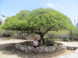
Marilyn Under a Shady Tree Out of the Sun
Cactii Fence Along Unpaved Roads
Typical Landscape over the Island
Cactii Which was Abundant All Over The Island

ARUBA DUTCH ANTILLES


FRIDAY 27Th JULY 2012.

Following one and a half days sailing in calm seas across the Western Caribbean we reached the small Caribbean island of Aruba in the Dutch Antilles. It was a hot and humid but sunny day of about 29 degrees. Aruba is situated about 15 miles off the coast of the South American country of Venezuela.

This island  is totally different to the previously visited tropical island of St Thomas in the Virgin Islands. It is very flat and dry and we did a half day trip around the island to get an idea of the lay of the land. It is obviously a very poor island, particularly once you get out of the capital Oranjestad. The countryside is a mixture of scrubby small trees and cactii, and whilst the housing is extremely colourful, the properties are generally unkept and untidy. However it has beautiful white sandy beaches and crystal clear water so typical of the Caribbean. Oranjestad is also a sea of colour which is a feature of the Dutch colonialism. Worth the visit But would not be in a hurry to come back.

We now have another sea day before we transit the Panama Canal through to the Pacific Ocean.


Friday, 27 July 2012

PHOTOGRAPHS ST THOMAS VIRGIN ISLANDS

Entrance to St Thomas Harbour From Ship
Sunset Sail Away
Port of St Thomas
Capital of St Thomas Charlotte Amalia
General View of Magens Bay And Beach
Magens Bay & Beach
Marilyn & Warwick Overlooking Magens Bay
Magens Beach
Marilyn In Water at Magens Beach
Warwick in Water at Magens Beach
Our Tour Transport
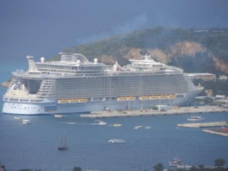
"Allure Of  The Seas" In Port
"Allure of The Seas"  Crossing Our Bow on Sail Away

Thursday, 26 July 2012

ST THOMAS VIRGIN ISLANDS


WEDNESDAY 25th JULY 2012.

After three days sailing from New York through the Atlantic, the Bermuda Triangle, the Saggasso Sea and the Caribbean in calm seas we reached St Thomas in the Virgin Islands safe and sound with no mysterious incidents occurring or seaweed blocking our way. It was warm and humid but a beautiful sunny day of about 28 degrees.

During the voyage two people on board became seriously ill and had to winched from the back of the ship to two American Coastguard helicoptors and taken to the island on San Juan for treatment.

St Thomas is as an American Caribbean Island about 14 miles long and 4 miles wide, typically lush and green with beautiful tropical scenery and hilly interior. As it was a fantastic day we decided to do a general tour of the Island which included a 2 hour visit to Magens beach which is well known as one of the best beaches in the Caribbean and also a visit to Blackbeard’s Castle and Amber Museum and shopping in it’s capital of Charlotte Amalia.

The Magen’s beach area certainly lived up to it’s name and reputation. A beautiful white sandy beach, palm trees and crystal clear water. The water was warm and great to swim in and it was two hours of bliss well spent. Blackbeard’s Castle and Amber Museum was a typical tourist complex, but included sampling of the locally made rum which came in eight different flavours plus a tour of two historical homesteads which took you back to the late 1800’S. Well worth the visit.

The capital of Charlotte Amalia is a bussling sea side tourist town, whose main street is principly a street of duty free jewellery and liquor shops, catering for money laden tourists with many of the shops owned or partly owned by the shipping companies.

A strange situation exists on the island with vehicles driving on left as in Aust, but all the vehicles are left hand drive. Apparantly this is a throw back from when the island was previously under British rule.

All in all it was a good day and topped off on the sail away with largest cruise liner in the world, “Allure of The Seas” crossing our bow as we left the port. This ship is some 230,000 tons and dwarfs the Sun Princess which is 77,000 tons. It also takes up to 6,000 passengers. A very big and magnificent ship.
Next port of call is the Dutch Antilles Island of Aruba in two days time.

Monday, 23 July 2012

PHOTOGRAPHS NEW YORK

Early Morning Entry to Upper New York Bay
Marilyn On 70th Floor of Rockefeller Centre with Empire State Building in Backroond
Ground Zero
Partly Completed Second Tower World Trade Centre
Freedom Tower World Trade Centre
Brooklyn Bridge
Empire State Building
Freedom Tower Building In World Trade Centre
Hudson River with World Trade Centre Biulding in Lower Manhattan
Statue of Liberty
Marilyn in Front Of Statue of Liberty
Ellis Island
Entrance to Ellis Island Immigration Facility
Manhattan From Ellis Island
Mariln in Front of Manhattan Skyline
New York and Manhattan Skyline on Sail Away
Warwick on Stern of Ship With Lower Manhattan in Backround on Sail Away
The Verrazano Narrows Bridge at Entrance to Upper New York Bay